When I started my career in surveying, the tools available to us were a clipboard, a damp meter, a torch and a lot of experience. Those fundamentals haven't changed — but the technology available to supplement them has come a long way. Thermal imaging is one of the most significant advances in residential property surveying of the past decade, and it's changing what we're able to find for our clients in Esher and across Surrey.
What Is Thermal Imaging?
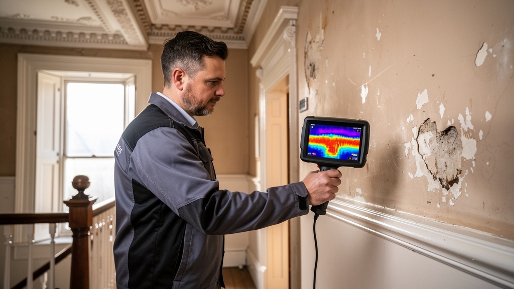
A thermal imaging camera — also called an infrared camera or thermographic camera — detects the infrared radiation emitted by surfaces. In practical terms, it creates a colour-coded image showing the temperature distribution across a surface. Warm areas appear red and orange. Cool areas appear blue and purple.
This is useful in a building survey context because temperature differences are often symptomatic of underlying issues: moisture makes surfaces cooler, heat escaping through gaps in insulation shows up as warm spots, and cold bridges reveal where the thermal envelope of the building is compromised.
What Can Thermal Imaging Detect?
Used correctly and in the right conditions, thermal imaging can reveal:
- Hidden moisture and damp: Wet areas in walls, floors and ceilings are typically cooler than the surrounding dry material. Thermal imaging can identify moisture behind finished surfaces that wouldn't be detectable visually.
- Insulation defects: Missing or poorly installed insulation in cavity walls or under floors appears as a cooler zone on thermal imagery during cold weather. This is particularly useful for assessing the energy efficiency of older Surrey properties.
- Cold bridges: These are paths of relatively high thermal conductivity in the building fabric — typically structural elements like steel lintels, concrete frames or uninsulated junctions — where heat escapes more rapidly. Cold bridges are not just an energy efficiency problem; they can also cause localised condensation and mould growth.
- Air leakage: Gaps and cracks where cold external air infiltrates the building envelope show up clearly on thermal imagery.
- Electrical hotspots: Overloaded or failing electrical circuits can show up as localised warm areas on thermal imagery — a potentially valuable early warning of fire risk.
- Underfloor heating faults: Many homes in the affluent Esher and Cobham area have underfloor heating systems. Thermal imaging can reveal breaks or blockages in the heating circuits beneath the floor finish.
The Limitations: What Thermal Imaging Can't Do
It's important to be honest about what thermal imaging cannot do. It's a tool — a powerful one, but a tool nonetheless — and it has limitations:
- It requires a sufficient temperature difference between inside and outside to produce meaningful results. In summer, when temperatures are similar on both sides of the wall, thermal imaging is much less effective for detecting insulation issues.
- It detects surface temperatures, not absolute moisture content. The findings need to be interpreted by an experienced professional alongside other measurements (moisture readings, visual inspection).
- It cannot look through thick masonry walls with any reliability — the further the problem is from the surface, the less clearly it shows up.
"I used thermal imaging on a 1970s bungalow in Esher last winter. The owners were proud of the fact it had been completely renovated — new kitchen, new bathroom, fresh plaster. The thermal survey showed a 2-metre section of the rear bedroom wall with significant moisture signature that the new plaster had completely hidden. A damp meter confirmed active moisture. Further investigation revealed a failed cavity tray above a window opening."
When Is Thermal Imaging Most Valuable?
Thermal imaging is most useful as an addition to a comprehensive Level 3 building survey on older properties, particularly during the autumn and winter months when the temperature differential between inside and outside is greatest.
It's particularly valuable for:
- Properties where damp is suspected but not obviously visible
- Properties with cavity wall insulation (to verify it's present and properly installed)
- Older solid-wall properties where understanding moisture patterns is important
- Newly renovated properties where fresh surfaces may be concealing defects
- High-value properties where the most thorough possible investigation is justified
The Future of Property Surveys
The direction of travel in residential property surveying is towards increasing use of technology — not to replace the surveyor's expertise and judgement, but to augment it. Alongside thermal imaging, drones are beginning to be used for roof and external inspections on complex or high buildings where access is limited. Moisture mapping technology is becoming more sophisticated.
What doesn't change is the need for an experienced, qualified professional to interpret the data, understand its context, and translate the findings into clear, actionable advice for the buyer. Technology tells you what — it takes a good surveyor to tell you why it matters and what to do about it.
Frequently Asked Questions
Want the Most Thorough Survey Available?
Our Level 3 building surveys use the latest technology alongside expert knowledge. Get a free quote for your Esher or Surrey property.
Get a Free QuoteRelated articles: Surveying Period Properties | Level 2 vs Level 3 | Our Level 3 Survey Service